Let Me Upgrade You!!
In my STEAM class, Urban Planning, we are in our last unit, Flow. We have been studying how different cities have different styles of urban planning. We visited the Pedway Tunnels for an FE which was really cool because I don't take public transportation, except for when I am going on an FE, and it was amazing seeing the way that the architects designed this underground tunnel for people when the weather is looking rough. We watched 3 different Ted Talks but they were all about urban planning. James Kunstler talked about urban planning "disappointing cities". Ellen James Dunham talked about turning dead malls into community spaces for the people that live in the same area. Majora Carter spoke on getting more green spaces in under privileged neighborhoods. I agree with Dunham and Carter because what they are trying to do is make communities better and stronger for the people that live in the same space/ area. For this AP, we had to take a place anywhere in the world and design it so that it makes the community better. Down below you will see the neighborhood that I want to design, a redesign, a labeled sketch, and google map images. Enjoy!
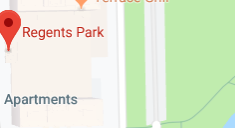
This is a screenshot of the community that I wanted to redesign. I chose Hyde Park, more focused on where the Regents Park buildings are located and some of Jackson Park is also placed. I chose this area because I use to in live in these exact buildings when I was younger and I always wanted to know why no one ever decided to build some thing near the buildings instead of having Jackson Park taking up to much makeup.
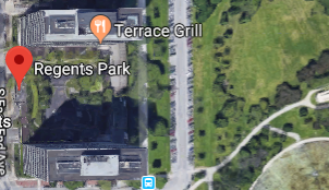
Here is a satellite image of the community that I am redesigning. This picture gives you more detail and it gives you more details on what the space looks like. I found this helpful when I had to think about what I wanted to put in my redesign.
This is a labeled image of what my redesign would look like. For my design, I added a target with a parking lot next to it t (red T & white PL). There is a Mariano's on the other side of it with a parking lot on the side of it (red M & with PL). The blue circle symbolizes an eating table that is out for people to eat on in the park so that they can eat and have a beautiful view of the park. The black line represents a bike lane that I added to the street because this lane is very busy since it comes off of Lake Shore Drive (the street with the black line going over it.) A bike lane would help bikers cross the bridge to get to the other side because it would take even longer having to go around LSD to find the entrance to the bridge to cross. I also wanted toads affordable housing to Regents Park, because there are so many empty apartments in this building because the rent is to high and people can not afford to live here.
These are my calculations for this AP. I had to measure two of the the five redesigned models. I chose to find the volume of the food bench and the volume of Regents Park. I got to make up the numbers for these measurements.
This is my redesign of the Regents Park area. The red box that is closest to the Regents Park building is Target and the grey rectangle next to, closer to the edge, represents a parking lot that I put because it wouldn't be fair for people to park on the streets since there are people who live in Regents or the area and need a space to park their car. The half sphere represents a food bench that I placed in the park in case people ant to eat and have a nice view of Jackson Park. The long dark grey street is a bike lane that I added because there are residents who bike and other people that bike through this street and there isn't a lane put down for bike lanes. On the other side of the bike lane, there is a red shape and another grey space and those represent a Mariano's and a parking lot by it's side. The last urban planning design that I wanted to add that doesn't appear in the 3D design is affordable housing. The Regents Park buildings has open apartments for people to rent their spaces out but the problem is, Regents Park cost too much for certain people. So affordable housing would help the community grow and become strong.
This design was inspired by the area in Hyde Park were there is a Walgreen's and a bus stop on the corner of 55th St. The exact space is called Hyde Park Shopping Center. There are spaces to grab food, sit down and eat, shop, etc. I wanted for Regents Park to be able to have some places where their residents could go and grab things without having to drive places and losing your parking spot.
SDG's
"11.2 by 2030, provide access to safe, affordable, accessible and sustainable transport systems for all, improving road safety, notably by expanding public transport, with special attention to the needs of those in vulnerable situations, women, children, persons with disabilities and older persons."
"11.7 by 2030, provide universal access to safe, inclusive and accessible, green and public spaces, particularly for women and children, older persons and persons with disabilities."
My redesign connects to both SDG's 11.2 because I am making an accessible, safe, and sustainable transport system, which is the bike lane that I added to the street. This bike lane would be accessible for anyone is biking in the area or needs a lane so they can make it to the park from being on the streets with cars. It will be safe because it is a lane for bikes only and people can get pulled over for driving in bike lanes. It would also be sustainable because its a lane and it doesn't waste energy. It relates to SDG 11.7 because I am bringing more people to the Jackson Park area by adding stores and food benches in the area.
 |
| Google Maps, Regents Park (2019) |
 |
| Google Maps, Satellite View of Regents Park (2019) |
 |
| Google Maps & KRM, Satellite View of Regents Park with Labels (2019) |
 |
| KRM, Calculations (2019) |
Here is the quote from the person I interviewed.
"I think that there needs to be more stores available for people that aren't so far away and I think that there needs to be affordable housing." - Close Friend
3D Model
My redesign connects to both SDG's 11.2 because I am making an accessible, safe, and sustainable transport system, which is the bike lane that I added to the street. This bike lane would be accessible for anyone is biking in the area or needs a lane so they can make it to the park from being on the streets with cars. It will be safe because it is a lane for bikes only and people can get pulled over for driving in bike lanes. It would also be sustainable because its a lane and it doesn't waste energy. It relates to SDG 11.7 because I am bringing more people to the Jackson Park area by adding stores and food benches in the area.
Peter Calthorpe
My redesign connects to creating a mixed use neighborhood because there is a park, transportation, stores and public space in one neighborhood. It also utilizes the transportation factor since I involved bike lanes and bus access. The last principal my design uses is localization. I brought in the Target and the Mariano's so people won't have to travel a farther distance to get what they need.
In conclusion, my time hear at GCE has come to an end. I am so happy that I was able to have Adam as a teacher because he has helped me in many ways without even knowing. With this AP, I changed my design towards the last minute and I am happy that Adam was able to work with me and help me with getting everything done. Something that I struggled with was making the 3D design for this AP. I started to make my 3D design on Minecraft but I didn't really like the way my design was coming out so I switched and used Tinkercad. I think that I did good with my calculations because I got to make up the numbers which made it easier for me. This AP was so fun and I am so happy that I ended my junior year with a strong project. I can't wait to see what life has for me and I hope that you were able to learn new information from my AP. Thank you!

Comments
Post a Comment